- Rating: EF-0
- Beginning Location: Near Red House, WV (38.5284, -81.8941)
- End Location: 1 mile west of Winfield, WV (38.5301, -81.8892)
- County: Putnam
- Start Time: 3:23 p.m.
- End Time: 3:24 p.m.
- Estimated Peak Wind: Unknown
- Path Length: 0.29 miles
- Path Width Maximum: 75 yards
- Fatalities: 0
- Injuries: 0
- Property Damage: $10,000
Details from NWS storm survey: During the early morning hours of May 26th, parts of northern West Virginia were observing flash flooding as the result thunderstorms that produced heavy downpours the previous evening. Over two and a half inches of rain fell in spots across Taylor and Harrison Counties, which led to high water issues on local roads in the county. Flooding concerns subsided just before sunrise. Later on that afternoon on the 26th, a bowing line of thunderstorms pressed into the Central Appalachians and caused widespread tree and power line damage. This line of convection had a history of producing strong wind gusts on the upwards of 60 miles per hour or greater as it crossed through the Tennessee Valley, and that remained the case during its journey through West Virginia. Storms first pressed into Mingo and Cabell Counties shortly after 2 PM and then overtook the bulk of the state through the afternoon and evening hours. Storms sprinted northeastward on the evening of the 26th out of the area. Strong downbursts with storms set forth extensive tree damage throughout the forecast area. An NWS Storm Survey was conducted in Fayette County, finding tree damage indicative of a microburst with peak wind speeds of up to 110 miles per hour. Elsewhere, winds closer to 50-60 miles per hour promoted localized single to multiple downed trees. A few brief tornadoes spawned on the leading edge of this bowing segment that afternoon. In West Virginia, an EF0 tornado occurred in the town of Winfield in Putnam County, resulting in tree and minor home damage. A brief EF0 tornado began near the intersection of Radwin Drive and Hazel Circle in Winfield, where trees were damaged and soffit/siding damage occurred to a home. The tornado continued in a northeasterly direction, moving across the ballfields behind Winfield Elementary School. A video posted to social media then showed the tornado continuing into the Courtyard Estates neighborhood where some minor tree damage occurred before the tornado dissipated. This is the 9th known tornado in Putnam County and the 3rd so far this year.
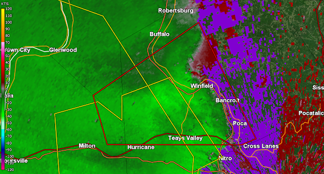
Radar Imagery
Base Reflectivity Near Time of Tornado
Base Velocity Near Time of Tornado
Normalized Rotation Near Time of Tornado
4-Panel Loop


